RIM - Riverscapes Inundation Mapper
The Riverscapes Inundation Mapper Tool, or RIM, was developed as part of Karen Bartelt's Thesis (Bartelt et al. 2021) to aid in the efficient mapping of structurally forced inundation patterns in beaver impacted riverscapes. RIM has since been published in Bartelt et al. (2025) and the RIM mapping procedures and metrics have been incoprorated into various protocols (e.g. LTPBR V2 inside Riverscapes Sudio - QRiS.
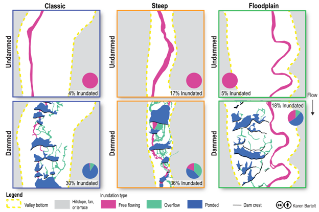
The contrast in inundation patterns and types in undammed (top) and dammed (bottom) situations, across dramatically different riverscape settings (left to right) produces a strikingly similar impact. That is, at the same baseflows, inundation is increased from 2 to 7 fold with a greater diversity of flow types (i.e. more ponded and overflow areas instead of just free flowing).
View or Download Projects
View or Download Projects from Bartelt 2021 and Barelt et al 2025 using Riverscapes Viewer
The types of beaver dam building activity impacting riverscapes that RIM was designed to capture and distill:
References
Bartelt KM, Belmont P, Gilbert JT, Hammill E, Macfarlane WW, Saunders WC, et al. (2025) Mapping valley bottom inundation patterns from beaver dam activity: A potential proxy for hydrologic inefficiency. PLOS Water 4(11): e0000428. DOI: 10.1371/journal.pwat.0000428
Bartelt K. 2021. Valley Bottom Inundation Patterns in Beaver-Modified Streams: A Potential Proxy for Hydrologic Inefficiency, Masters Thesis, Utah State University: Logan, UT. Available from: https://digitalcommons.usu.edu/etd/8226. DOI: 10.26076/a66b-0708.