Step 4: Calculate Metrics
Calculate metrics
Run this script to calculate summary metrics from the features mapped in the DCEs
Inputs:
- project_path - The path to a folder where you want the project folder structure to be created
- RS_folder_name - The name of the folder with RS Context shapefiles you want to use to calculate site metrics (the folder with the Valley Bottom polygon)
- DEM - The path to the input DEM
Site or project parameters
- project_name A readable name of the site
- site_name The shorthand name of the site
- huc8 - the 8 digit Hydrologic Unit Code
- setting - the dominant beaver dam building opportunity present ("classic", "steep", or "floodplain")
Metadata and parameters describing both DCEs that will be compared
- DCE1_name - the name of the first DCE folder you want to use for the metric calculation (e.g. "DCE_01")
- DCE2_name - the name of the second DCE folder you want to use for the metric calculation (e.g. "DCE_02")
DCE 1 parameters
- DCE1_date - the date that the imagery was acquired
- DCE1_flow_stage - the flow stage at the time of the imagery (e.g. low, moderate, high)
- DCE1_active - was there evidence of recent beaver activity at the site during the time of the imagery acquisition?
- DCE1_maintained - was there evidence of recent beaver dam maintenence at the site during the time of the imagery acquisition?
- DCE1_res - the resolution of the input imagery in meters
DCE 2 parameters
- DCE2_date - the date that the imagery was acquired
- DCE2_flow_stage - the flow stage at the time of the imagery (e.g. low, moderate, high)
- DCE2_active - was there evidence of recent beaver activity at the site during the time of the imagery acquisition?
- DCE2_maintained - was there evidence of recent beaver dam maintenence at the site during the time of the imagery acquisition?
- DCE2_res - the resolution of the input imagery in meters
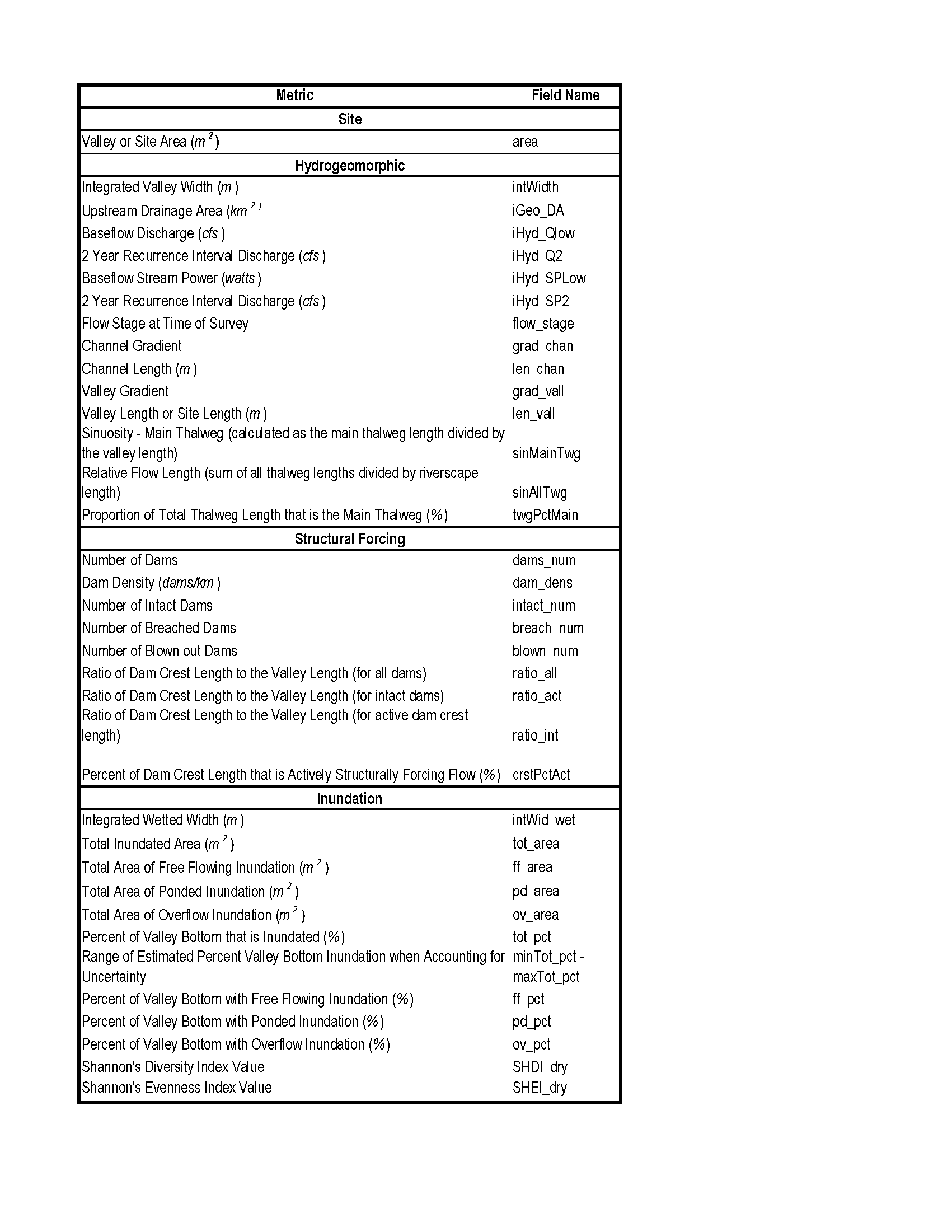
Output Metrics
The following table includes all metric outputs